
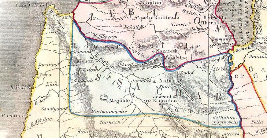
What You Are Looking At
This 1852 Philip map shows the territories of two neighboring tribes: Issachar and Zebulun. The broad letters I S S A C H A R are written across the central portion, while Z E B U L O N appears at the top of the map in pink shading. Together these two tribes occupied the richest agricultural corridor in the entire Promised Land — the Jezreel Valley (labeled here as the Plain of Esdraelon) and the hills of Lower Galilee. The strategic city of Megiddo is marked in Issachar’s territory — the guardian of the Jezreel Valley’s main pass. Nazareth appears in Zebulun’s territory in the lower Galilee hills — the town where Jesus of Nazareth would grow up nearly thirteen centuries after this allotment was made. Mount Tabor (M. Tabor) is visible near the junction of Issachar, Zebulun, and Naphtali — the mountain where Deborah and Barak assembled their forces. The Sea of Galilee (Sea or Lake of Tiberias) forms the eastern boundary at the right side. Cape Carmel appears at the upper left. The Kishon River runs through the valley — the river that swept away Sisera’s army (Judges 4–5).
“The third lot came up for the children of Zebulun according to their families... And the fourth lot came out to Issachar, for the children of Issachar according to their families. And their border was toward Jezreel, and Chesulloth, and Shunem... And the border cometh down to the valley of Jezreel.”
The Jezreel Valley — Battlefield of the Ages
The two tribes of Issachar and Zebulun shared the most strategically significant valley in the entire land of Canaan: the Jezreel Valley, also called the Plain of Esdraelon. Running diagonally from the Jordan River in the southeast to the Mediterranean coast at the foot of Mount Carmel in the northwest, this great valley was the agricultural heartland of the north and the main military corridor connecting Mesopotamia with Egypt. Every major power that moved through the ancient Near East passed through the Jezreel Valley. The city of Megiddo, at the key pass through the Carmel ridge, guarded the entrance to this corridor and witnessed more battles than almost any other site in the ancient world. The name “Armageddon” in the book of Revelation is derived from the Hebrew “Har Megiddo” — the hill or mountain of Megiddo.
Zebulun — The Tribe of Galilee
Zebulun’s territory occupied the hills of Lower Galilee between the Jezreel Valley to the south and the territory of Asher and Naphtali to the north. Jacob’s blessing in Genesis 49:13 — “Zebulun shall dwell at the shore of the sea” — suggests a maritime orientation, and Zebulun’s location in the Galilee hills placed it within easy reach of the trading routes connecting the coast with the interior. But Zebulun’s most lasting significance in biblical history comes from a prophecy in Isaiah 9:1–2: the land of Zebulun and the land of Naphtali, once “brought into contempt,” would be honored when “the people who walked in darkness have seen a great light.” This prophecy was quoted by Matthew (4:14–16) in direct connection with Jesus beginning His ministry in Galilee — in Nazareth, a city in Zebulun’s territory, and around the Sea of Galilee, which bordered Zebulun and Naphtali.
Issachar — The Tribe of the Valley
Issachar received the broad Jezreel Valley floor and the eastern approaches toward Beth-shean and the Jordan. Jacob’s poetic blessing described Issachar as “a strong donkey lying down between two burdens” who “saw that rest was good, and that the land was pleasant” (Genesis 49:14–15) — a tribe associated with agricultural wealth and the willingness to accept hard labor in exchange for good land. The Issacharites had a reputation for wisdom: 1 Chronicles 12:32 notes that men of Issachar were “men who had understanding of the times, to know what Israel ought to do.” From Issachar’s territory came Deborah’s battle against Sisera (Judges 4–5), which was fought in the Jezreel Valley along the Kishon River.