
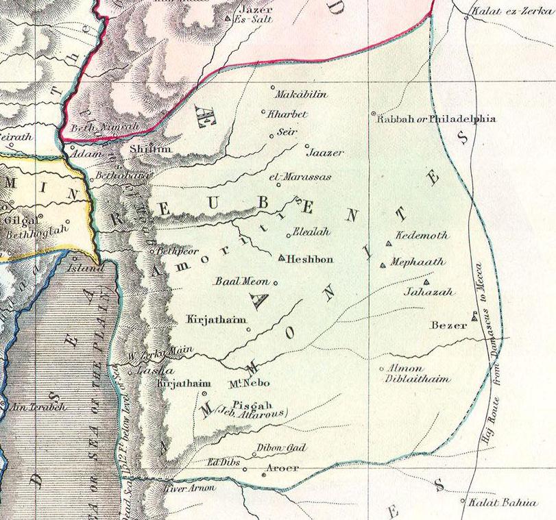
What You Are Looking At
This 1852 Philip hand-coloured map shows the territory of the Tribe of Reuben, whose land is displayed in the light green shading with the letters R E U B E N written across it. The Dead Sea (Salt Sea) is visible along the left edge, with the Jordan River running along the western boundary. The map is directly relevant to the Ehud narrative because Reuben’s territory directly bordered Moab — Moab’s cities of Heshbon, Dibon-Gad, Aroer, and the River Arnon (Moab’s traditional northern boundary) are all visible on the map. Mount Nebo and Pisgah appear in the southwest portion — the mountain from which Moses viewed the Promised Land. Bezer, one of the six Cities of Refuge, is labeled in the eastern portion. Along the Jordan Valley at the top of the map, Adam and Beth Nimrah mark the area near the Jordan fords — the precise location where Ehud led Israel to seize the crossing and destroy the Moabite army. Gilgal is labeled at the top left — the Israelite base camp from which Ehud had departed.
“And Ehud came unto him; and he was sitting in a summer parlour, which he had for himself alone. And Ehud said, I have a message from God unto thee. And he arose out of his seat. And Ehud put forth his left hand, and took the dagger from his right thigh, and thrust it into his belly.”
Moab Occupies the City of Palms
Eighteen years after Othniel’s forty-year peace ended, Israel again did evil in the sight of the Lord and God strengthened Eglon king of Moab against Israel. Eglon united the Ammonites and Amalekites with Moabite forces and crossed the Jordan to occupy Jericho, called in Scripture the “City of Palms” — the ancient city Joshua had burned three centuries earlier now rebuilt and serving as Eglon’s administrative seat. From Jericho, Moab extracted tribute from Israel for eighteen years.
Reuben’s tribal territory lay directly east of the Dead Sea and the Jordan, occupying the Transjordanian plateau between the River Jabbok to the north and the River Arnon to the south. Moab’s territory began at the Arnon. This geographic relationship meant Reuben lived under the shadow of Moabite pressure: Moab had historically claimed much of the territory assigned to Reuben (including Heshbon, Dibon, and Bezer), and the two peoples shared a long and contested border. Reuben’s land formed the corridor between Moab’s heartland and the Jordan River crossing — the exact route by which Eglon moved his army to occupy Jericho, and by which Ehud later cut off the retreating Moabites.
Ehud the Left-Handed Benjaminite
God’s chosen instrument for deliverance was Ehud ben Gera, a Benjaminite — specifically described as “a man left-handed” (Judges 3:15). The Hebrew phrase used — itter yad-yemino — literally means “restricted in his right hand,” meaning his right hand was either unused or non-dominant. In the ancient world, a left-handed warrior could place his sword on his right thigh — the opposite side from where guards would search — and draw it across his body without detection. Scripture notes this detail not as biographical trivia but as the hinge of the entire narrative: it was precisely Ehud’s left-handedness, and therefore the placement of his concealed dagger, that made the assassination possible.
The Jordan Fords and the Eighty Years of Rest
After slaying Eglon and escaping to Seirath in Ephraim’s hill country, Ehud sounded the trumpet and led Israel down to seize “the fords of Jordan toward Moab” (Judges 3:28). These fords — the shallow crossing points of the Jordan north of the Dead Sea, visible on this map at the top left near Adam and Gilgal — were the only way for Moab to retreat from Jericho back to their own territory. By seizing the fords, Ehud trapped the Moabite garrison west of the Jordan, and Israel “slew of Moab at that time about ten thousand men, all lusty, and all men of valour; and there escaped not a man” (Judges 3:29). The result was eighty years of rest — the longest period of peace in the entire book of Judges.