
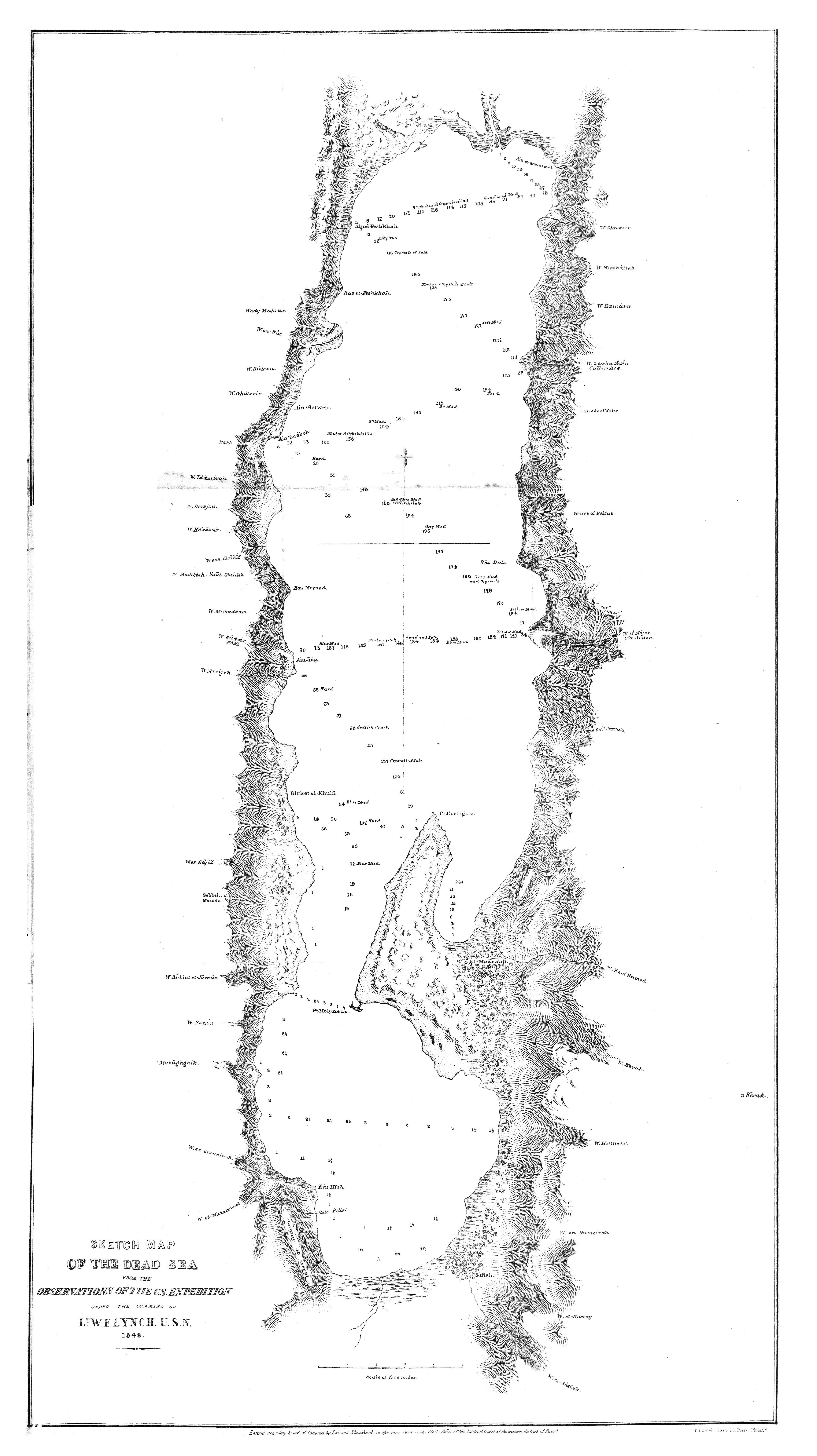
The map before you is not a biblical illustration. It is a scientific survey — the first systematic measurement of the Dead Sea ever conducted, carried out in 1848 by Lt. William Francis Lynch of the United States Navy at the direction of the Secretary of the Navy. Lynch's expedition launched two metal boats on the Jordan River, floated them down to the Dead Sea, and spent weeks sounding its depths, mapping its shores, and recording its extraordinary geographical features. What they found confirmed what biblical geography had always suggested: this is one of the most unusual bodies of water on the face of the earth, and its southern reaches bear the unmistakable character of catastrophic destruction.
Look at the depth soundings on this map. In the northern basin — the upper two-thirds of the map — the numbers run deep: 100, 150, 180, even over 200 fathoms in places. This is one of the deepest lakes in the world. But now look at the southern basin below the Lisan Peninsula. The depth soundings drop to single digits — 1, 2, 3, 4 feet. The southern end of the Dead Sea is extraordinarily shallow, in some places barely navigable. This dramatic difference between north and south has fascinated biblical geographers for centuries, because it corresponds precisely to where Genesis locates the Vale of Siddim and the Cities of the Plain.
Genesis 14:3 explicitly identifies the Vale of Siddim with "the salt sea." The five cities — Sodom, Gomorrah, Admah, Zeboiim, and Zoar — were located in this valley. When Abraham looked from his camp near Hebron toward Sodom after the destruction, he saw "the smoke of the country went up as the smoke of a furnace" (Genesis 19:28). The Judean highlands west of this map — to the left — are the heights from which Abraham watched. The distance from Hebron to the southern Dead Sea is approximately 30 miles. On a clear morning, smoke rising from a burning plain would have been visible from those heights.
Archaeological excavations at Bab edh-Dhra and Numeira on the southeastern shore of the Dead Sea — in the shallow southern basin region shown at the bottom of this map — have found Bronze Age cities that were abruptly and violently destroyed around 2300–2000 BC. Both sites show evidence of intense burning. The excavators found thick ash layers, burned mudbrick, and charred wood. Both cities were abandoned immediately after the destruction and never rebuilt. These are not conclusive identifications with Sodom and Gomorrah, but they fit the biblical description with remarkable precision in time, location, and the nature of the destruction.
The Dead Sea itself is part of the story. The Jordan Rift Valley — the deepest land depression on earth — runs through this map from north to south. The region is geologically active, sitting on a major fault line. The bitumen pits mentioned in Genesis 14:10 — which proved fatal to the fleeing kings of Sodom and Gomorrah — correspond to actual petroleum seeps documented throughout the Dead Sea area. Sulphur deposits are found on its shores. The entire geological character of the region is consistent with the kind of catastrophic event Genesis describes: fire and brimstone falling from the sky, the entire plain overthrown. Whether through volcanic activity, earthquake-triggered gas explosions, a meteor strike, or direct divine intervention — or all of the above — the landscape you are looking at on this map bears the marks of something that happened here that the earth has never forgotten.