
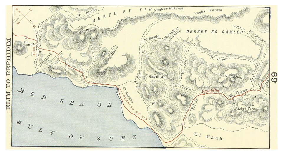
Look at this map carefully. The rugged terrain you see — the packed mountain ranges, the narrow coastal plain along the blue Gulf of Suez, the deep wadis cutting through the rock — is exactly what Israel was marching through in the first weeks after leaving Egypt. These were not easy roads. The Sinai Peninsula is severe, dry, and demanding. But God had led them here deliberately, and every hardship served a purpose.
Find Elim in the upper-left. This was the good news after Marah — after Israel arrived at bitter water and Moses threw in the tree God showed him to make it sweet. Elim had twelve springs and seventy palms (Exodus 15:27). Israel camped here and rested. But the march continued south and east. Find the Wilderness of Sin in the center of the map — the broad plain between the mountains and the sea. It was here, about six weeks after leaving Egypt, that the food supply they had brought from Egypt ran out.
The murmuring at this point is understandable in human terms. Six weeks in the wilderness, food gone, no farming possible. "Would to God we had died by the hand of the LORD in the land of Egypt, when we sat by the flesh pots, and when we did eat bread to the full" (Exodus 16:3). This is the first of many complaints that will mark the wilderness years — and God's response is characteristic: not anger, but provision. He rained manna from heaven in the morning and quail in the evening. Every day. Except the Sabbath. For forty years.
Follow the red route east to Rephidim. Find it labeled in the right portion of the map among the mountains. At Rephidim there was no water, and the people were ready to stone Moses. God told him to strike the rock at Horeb — "and thou shalt smite the rock, and there shall come water out of it" (Exodus 17:6). Then the Amalekites attacked. Joshua led the army; Moses stood on the hill with his hands raised; when his hands fell from exhaustion, Israel lost ground. Aaron and Hur held his arms up all day. Israel prevailed. And then — just beyond Rephidim, around the next mountain — they arrived at Sinai.