
The Full Conquest of Canaan Under Joshua
Joshua 12:1–24
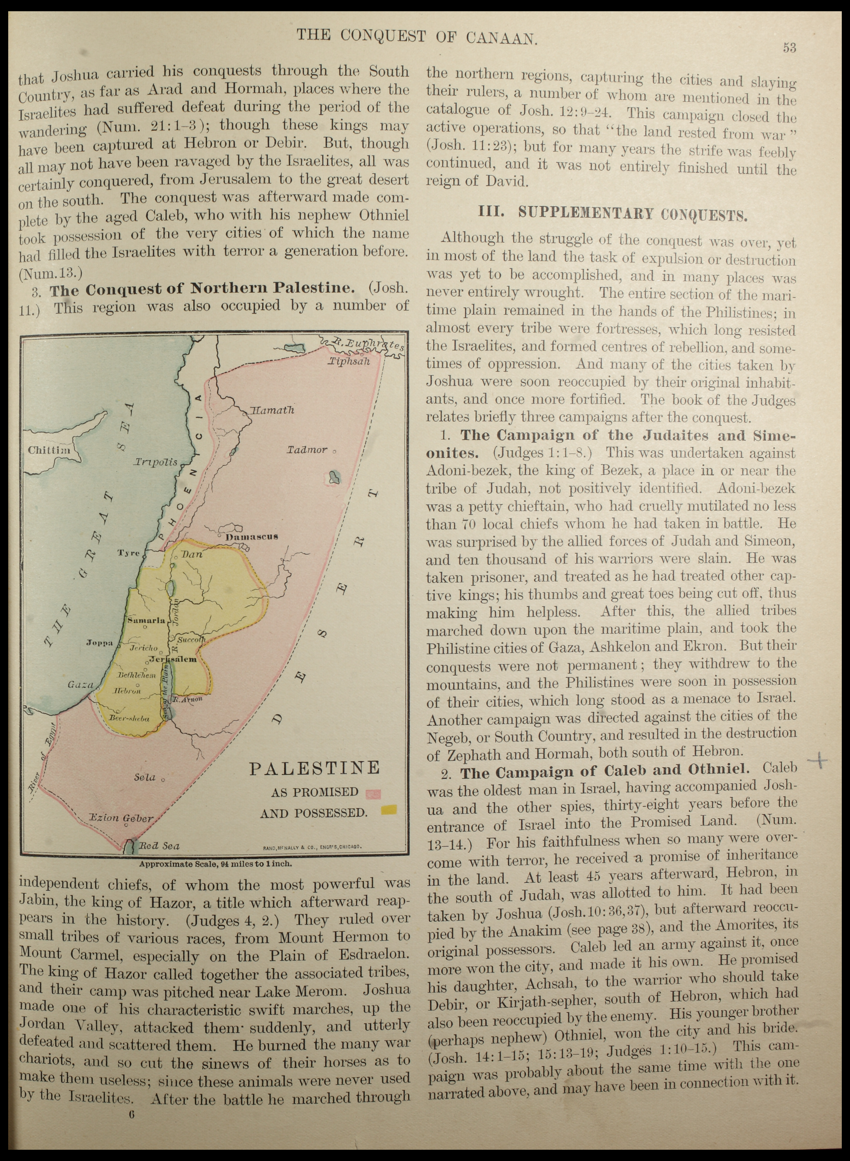
Palestine as Promised and Possessed — from Jesse Lyman Hurlbut's Manual of Biblical Geography (1904). The map contrasts the full extent of the covenant promise with the territory actually possessed under Joshua. Public domain.
What You Are Looking At
This page from Hurlbut's 1904 Manual of Biblical Geography contains the map titled “Palestine as Promised and Possessed,” one of the most theologically significant maps in biblical geography. Two territories are distinguished by different shadings. The territory promised to Abraham in Genesis 15:18 extended from “the river of Egypt” (the Wadi el-Arish in the Sinai) to “the great river, the River Euphrates” — encompassing parts of modern Egypt, Israel, Jordan, Lebanon, Syria, and Iraq. The territory actually possessed under Joshua was considerably smaller: roughly the land west of the Jordan from Dan in the north to Beer-sheba in the south, plus the Transjordan territories taken from Sihon and Og under Moses. On the map, the city of Jericho is visible, along with Jerusalem, Samaria, Joppa, Gaza, Bethlehem, Hebron, and the River Arnon as the Moabite boundary. The surrounding text in Hurlbut's manual discusses the supplementary conquests and the cities that remained in Canaanite and Philistine hands. The map makes visually clear that even at the height of Joshua's conquest, Israel had occupied only a portion of what God had ultimately covenanted with Abraham.
“And these are the kings of the country which Joshua and the children of Israel smote on this side Jordan on the west... The king of Jericho, one; the king of Ai... one; the king of Jerusalem, one; the king of Hebron, one; the king of Jarmuth, one; the king of Lachish, one... All the kings, thirty and one.”
— Joshua 12:7–9, 24 (KJV)
The Catalog of Thirty-One Kings
Joshua 12 contains a list that readers tend to skip — the thirty-one defeated kings of Canaan. In reality it is a powerful theological document. Each “king” ruled not a large national territory but a city-state and its surrounding farmland, the characteristic political unit of Bronze Age Canaan. The list begins with Jericho and Ai, the first two conquests, and proceeds through the southern and northern campaigns. Taken together, the thirty-one city-states represented the political map of Canaan that God had promised to deliver into Israel's hands. Their defeat was the fulfillment of centuries of covenant expectation.
Archaeological work has confirmed the prominence and historicity of many cities on this list — Jericho, Ai, Jerusalem, Hebron, Lachish, Hazor, Megiddo, and Gezer are all well-attested sites with long occupation histories. The biblical list aligns remarkably well with what the Egyptian Amarna Letters and other ancient Near Eastern sources tell us about the political landscape of Late Bronze Age Canaan.
Promised vs. Possessed
The Hurlbut map captures an important and honest tension in the conquest narrative. The promise to Abraham was expansive — from the river of Egypt to the Euphrates. What Joshua actually secured was substantial but far smaller. Joshua 13:1 records God's candid assessment at the end of Joshua's campaigns: “You are old and advanced in years, and there remains very much land yet to be possessed.” The Philistine cities of Gaza, Ashdod, Ashkelon, Gath, and Ekron remained outside Israelite control, as did territories in the north around Sidon and the regions of Lebanon.
The incompleteness was deliberate. God had explained in Exodus 23:29–30 that He would not drive out the inhabitants all at once, lest the land become desolate — “little by little I will drive them out.” The remaining Canaanites were to serve as a test of Israel's covenant faithfulness. Yet throughout the Book of Joshua, the dominant note is not incompleteness but fulfillment. Joshua 21:45 declares: “Not a word failed of any good thing which the Lord had spoken to the house of Israel. All came to pass.”
© 2026 Michael Knighton | Christians Standing With Israel™ | All Rights Reserved